Seleccione el nombre del Concejo Territorial para ver su mapa correspondiente
Click on the name of the Concejo Territorial to see its map.
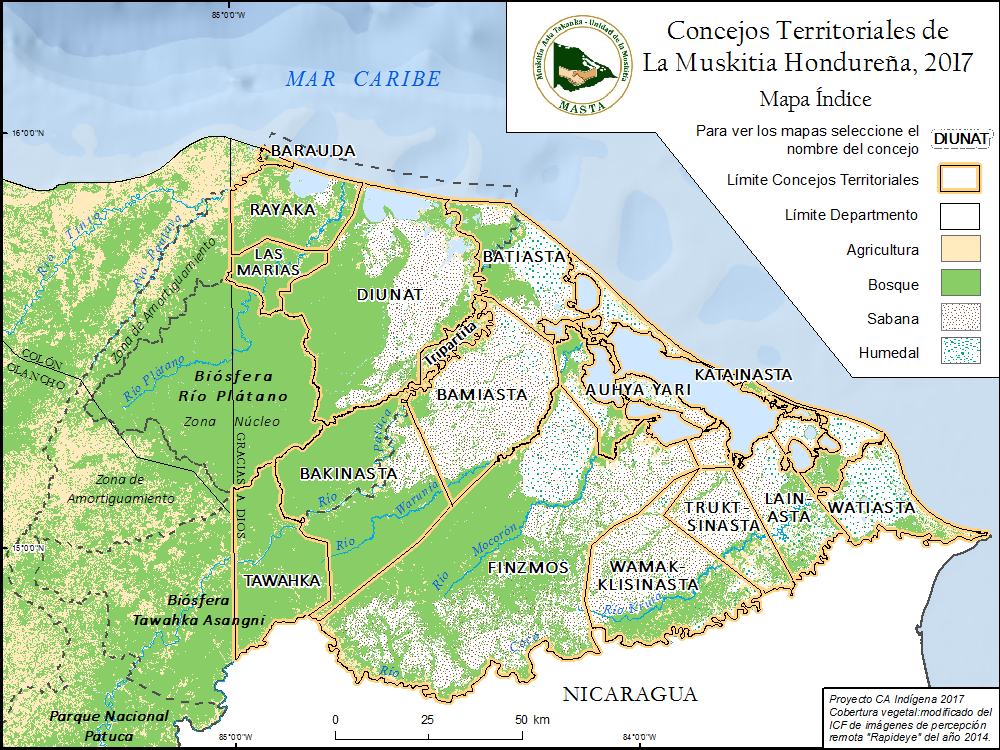
A partir de septiembre del 2014 hasta mayo del 2015, las comunidades Miskitas del nuevo Concejo Territorial KATAINASTA de La Mosquitia hondureña participaron en un proyecto piloto de investigación cartográfica participativa (ICP) para documentar sus tierras y usos de suelo. Los resultados cartográficos incluyen una detallada cartografía digital a gran escala de KATAINASTA, en la que se ubicaron cientos de topónimos indígenas y sitios de usos. Estos datos fueron generados y verificados cuidadosamente por los investigadores miskitos que se capacitaron como "geógrafos locales" y que trabajaron directamente con sus comunidades. Ahora el pueblo de KATAINASTA ha comenzado a usar estas herramientas para su educación local, manejo de recursos, gobernanza, desarrollo y más sobre todo en sus interacciones con agencias gubernamentales y ONGs.
Las federaciones indígenas MASTA y FITH han solicitado la continuación de la ICP y la formación de geógrafos locales. En octubre de 2015, dichas actividades se extendieron a siete concejos territoriales más: DIUNAT, BATIASTA, BAMIASTA, BAKINASTA, AUHYA YARI, WAMAKKLISINASTA y TAWAHKA. Hasta la fecha, sin embargo, no hay fondos disponibles para completar la cartografía de los cuatro CTs miskitos, el CT Pech y el CT Garífuna.
___________________________________________________________________________________________________________________________Las federaciones indígenas MASTA y FITH han solicitado la continuación de la ICP y la formación de geógrafos locales. En octubre de 2015, dichas actividades se extendieron a siete concejos territoriales más: DIUNAT, BATIASTA, BAMIASTA, BAKINASTA, AUHYA YARI, WAMAKKLISINASTA y TAWAHKA. Hasta la fecha, sin embargo, no hay fondos disponibles para completar la cartografía de los cuatro CTs miskitos, el CT Pech y el CT Garífuna.
From September 2014 to May 2015, the Miskitu communities inside the new Concejo Terriorial KATAINASTA of the Honduran La Muskita participated in a pilot participatory research mapping (PRM) project to detail their lands and land uses. The cartographic results included the precise large-scale digital mapping of KATAINASTA, plotting hundreds of indigenous toponyms and land use sites. These data were generated and carefully verified by Miskitu investigators who were trained as "local geographers" and who worked directly with their communities. The people of KATAINASTA are now beginning to use these tools in local education, resource management, governance, development, and more in their interactions with governmental and NGO agencies.
The indigenous federations MASTA and FITH requested a continuation of the mapping, and since October 2015, the PRM and training of local geographers has been extended to the concejos territoriales DIUNAT, BATIASTA, BAMIASTA, BAKINASTA, AUHYA YARI, WAMAKKLISINASTA, AND TAWAHKA. Presently, however, no funding is available to complete mapping the remaining four Miskitu CTs, the Pech, and the Garífuna CTs.
___________________________________________________________________________________________________________________________The indigenous federations MASTA and FITH requested a continuation of the mapping, and since October 2015, the PRM and training of local geographers has been extended to the concejos territoriales DIUNAT, BATIASTA, BAMIASTA, BAKINASTA, AUHYA YARI, WAMAKKLISINASTA, AND TAWAHKA. Presently, however, no funding is available to complete mapping the remaining four Miskitu CTs, the Pech, and the Garífuna CTs.
Gracias a todos los colaboradores; Thank you to all the collaborators.